Froggatt, Curbar and Calver is a Parish within Bakewell District Council, having written extensively about Curbar in a previous blog, it is now the turn of Froggatt to be highlighted.
Nestling below the escarpment of gritstone named after the village, Froggatt Edge, and with the River Derwent running ribbon like on its Western boundaries, the village is more linear than orbital.
Where does such an unusual name of Froggatt derive from?
Although there is no mention of Froggatt in the Domesday book, there is historic documentation of it being originally named in the 13th C as Froggecot, and a century later as Frogcot. It is likely that its name derived from two words, Frog and Cot. Frog being the home of many frogs, and Cot indicating a dwelling.
In the low lying and moist location, once home to seventeen natural springs, you can imagine it being an ideal home for our amphibian friends.
In the thirteenth century the manor of Baslow was divided into two moieties, (ownership), One going to the Vernon family and the other to the Bassetts. Froggatt or Froggecotes as it was known at the time was held by the Bassetts. In around 1290, John Froggecotes of Froggecotes bought land and property including a grove of trees from Simon Basset. This land, plus more that was purchased over time, remained in the family until 1752 when the senior branch of the family died out. John Froggecotes has many living descendants from a junior branch of the family headed by Thomas Froggott of Folds farm, Calver.
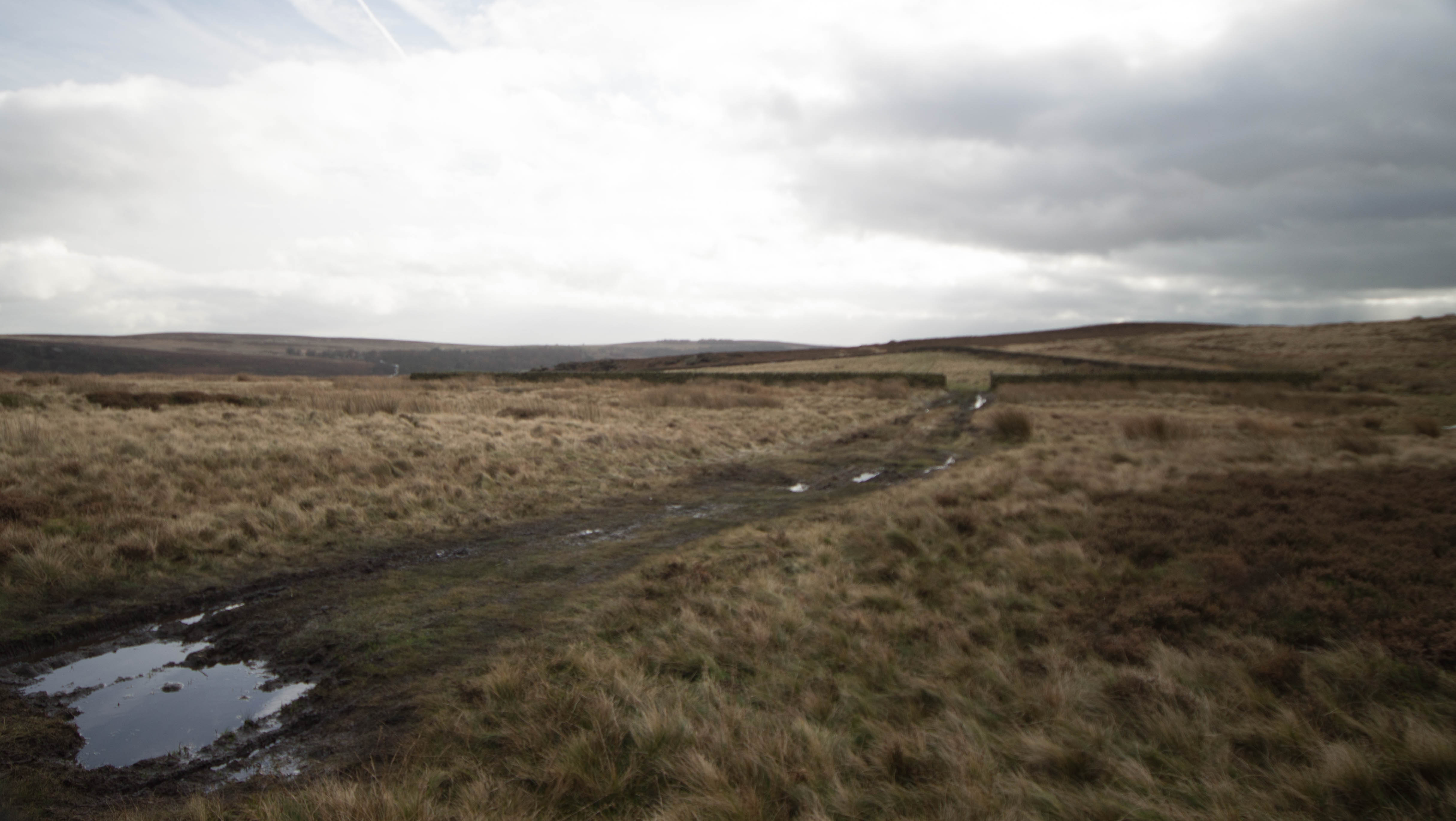
Spooner Lane bridleway
From the North, Spooner lane enters the village from Grindleford and Froggatt woods. You are grateful for the old bridleway flags that still exist from centuries past, as they give refuge to your feet from the muddy patches caused by spring water seeking its path downhill to the river Derwent below.
Passing by several of the seventeen picturesque and quaint cottages built by the Duke of Rutland as estate workers homes, brings you to the road junction of Moorlands Lane and the Grade II listed Rose cottage. All the Dukes cottages were included in the 1922 sale as part of the beginning of the break up of the Dukes Longshaw estates.
Rose Cottage
Across the road, sits the Wesleyan Reform Chapel founded in 1832 and eventually built in 1834. Although this is no longer a place of worship it is one of several Reform chapels left in the Peak District. It has seating for 100 people and was originally just the Wesleyan Chapel, but in later years they joined the reformists movement.
Wesleyan Reformists Chapel
Adjoined to the Chapel are several seventeenth century Grade II listed cottages. All in all, this is the most charming area of Froggatt village.
Continue on your journey through Hollow Gate, a Viking word for a sunken way, a raised footpath to your left raises the curiosity, but alas no documented reasoning for this exists.
Froggatt Bridge
The seventeenth century and perfectly formed Froggatt Bridge is the next place of interest. Built by the Stoney Middleton gifted builder, James Booth, the same person that built the octagonal church at Stoney Middleton and the rebuilding of Stoke Hall. Adorned with its two different styles of arches, two rounded arches and one central pointed arch, makes this a very unusual bridge. There is a story to the reason for this unusual configuration. When Calver weir was constructed further down stream, the river slowed and subsequently started to widen in parts up stream. This prompted the building of the second smaller arch to accommodate the new span of the river. With only room for one vehicle at a time, the twin refuge receptacles are a blessing and an ideal viewing point. Stoke Lane leads up to the toll bar at Stoke Hall mentioned in the history of my Grindleford blog.
Not quite opposite the bridge runs, The Green. A steep incline through a scattering of picturesque properties, all worthy of closer inspection. The road eventually turns into a path that appears on the Sheffield road. Turn right here to the Chequers Inn. A characterful former coaching inn that was part of the Duke of Rutlands Longshaw estate. Thought to have derived its name from the Dukes agent that would set up shop here using chequers to help in his accounting in the collecting of the rents from the villagers.
The Green Path
Jack Carnall and his sons Tommy and Albert, lived in one of the cottages below the Inn, and in around 1916 they were photographed resting after mowing and scything the grass.
Jack Carnall and sons
The original building on this site was built around 1591 when George Marples and his family lived there. It was opened as an ale house by Jacob Marples, one of Georges children. Legend has it that some local grave snatchers from Eyam, use to call here for the odd flaggon of ale before carrying out their macabre deeds in the graveyards of Sheffield. The present building was built in 1735 by Thomas Marples.
Present day Chequers Inn
The cottages, that were once upon a time separate dwellings to the Inn, have over the years become part of the old coaching inn but have nonetheless have lost non of their charm.
19th c Chequers Inn
Opposite the Inn, where the car park is now sited was Rileys cowshed, which was a place for the local population to get together to celebrate events. One such event was the coronation of King George VI and Queen Mary in June 1911.
Rileys Cowshed Coronation celebrations
A very interesting piece of Froggatt history was played out near to the Chequers Inn. An Holiday Fellowship building existed here after it took over the Froggatt Edge Guest House in 1923 and extended it to a further 20 bedrooms. during the next ten years there were 5,000 – 6,000 guests. The Holiday Fellowships were originally set up to give affordable holidays to the working classes, and still exist in varying forms all over the country. This particular one however, welcomed child refugees from the Spanish civil war. In October 1937, 25 children aged 7 to 15 years arrived with their Spanish female escorts, and stayed for six months. Over 4,000 child refugees were welcomed from General Francos Spain by Great Britain at the time.
Children being called to dinner at the Froggatt colony
More information can be found about this fascinating period by searching, “Basque Children Froggatt”.
Holiday Fellowship
Dining Room
Across from the Inn and at the bottom end of the car park, there are remains of an old building, just below this you can take a quite boggy path back down to the road at Froggatt and the Derwent.
Derelict building
On arriving at the tarmacked road, turn right back along the lane to Froggatt bridge. On your right just before the bridge, you will see a building called The Nurseries. Once upon a time this was the only dwelling to have running water. The lands used to run all the back down the lane to Riddings farm. Over the years and with influx of new people and with the demand for housing rising, new properties have replaced the once worked fields.
One final property worthy of mention is Frog Hall near the top of Moorlands Lane. Originally named Moorlands Hall and built for the industrialist, Charles Markham Paxton in the early 1800s when he bought most of the Haddon estate in the area.
Moorlands hall
Frog Hall
Thank you as always to the various sources of information that enables me to put everything in one place .
View of old Grindleford from the present Jubilee Gardens
Grindleford is often overlooked by the majority of the tourists to the Peak District. To some, nothing more than a conduit of roadways to the honeypots of the Peak District. Protected from the East, by the mighty ramparts of Froggatt Edge, with the more gentle backdrop from the West by Eyam and Leam Woodlands, and with the scything action of the iconic River Derwent travelling on its journey South from its humble beginnings high upon the Derwent moors. This is truly a valley village. Stop and explore, you will be amazed of the diverse history of this quiet and unassuming village.
It is suggested that the name of Grindleford possibly derives from when the grindstones, (grindlestones) were transported from the nearby quarries, across what would have been a ford in times before a bridge existed. Quarrying for the high quality stone in this area of the Peak, brought in a tremendous amount of work for the local population. Well known local names like, Tegness, Curbar, Froggatt, Tumbling Hill and Stoke, all had quarries and edges where the men worked for the prized gritstone.
The present bridge that spans the river Derwent today was built around 1758 and widened at a later date. Evidence of this widening of the bridge can be seen underneath the arches. The earliest documented bridge to be on this site, was in 1577, although an earlier wooden structure probably existed.
Grindleford parish extends to Stoke, Eyam Woodlands and Upper and Nether Padley where at the latter, Padley Chapel resides.
The second Padley Manor was built around 1415 when Robert Eyre returned from Agincourt to marry his sweetheart Joan Padley. They subsequently had 14 offspring, (no television in those days). Being devout Catholics, Robert also gave generously to the upkeep of St Michaels Church at Hathersage.
Padley Chapel frontage
On the 12th July 1588, and with the anti Catholic Queen Elizabeth I on the throne of England, two priests, Robert Ludlam and Nicholas Garlick, acting on behalf of the the Fitzherbert family, were found hiding within a Priests hole at Padley Hall. They were charged with high treason after holding an illegal mass at the Hall, and were taken to Derby, where they were found guilty and barbarically sentenced to be hung, drawn and quartered. Their gruesome remains were put on public display upon St Marys bridge in Derby as a warning to others.
The Chapel was apparently the former gatehouse to the original Padley Manor of the Bernak family who owned the manor and surrounding lands in the 13th century. During this time, the manor lands were let to the monks of Beauchief Abbey in Sheffield. The interesting and scattered remains of the hall can be seen around the rear of the Chapel grounds, where a spiral staircase is still obvious amongst the ruins..
Padley Chapel rear and ruins of Padley hall
The chapel was finally reconsecrated in 1933 when it came into the stewardship of the Roman Catholic church. An annual pilgrimage takes place in July of each year to remember the Martyrs of Padley.
Map of Area
Just metres above Padley Chapel you cross over a bridge that spans a man made gorge. This is the 300ft incline from Bolehill quarries to the main Midland Railway Hope Valley Line.
The Incline
In 1903, quarry work began at Bolehill. All the stone for the Dams at Howden and Derwent were quarried here and moved by rail to the dams in the Derwent valley. It is estimated that 1.25 million tons of stone were removed from an estimated 2.4 million tons of high quality silica gritstone. Some of the blocks weighed up to 30 tons, and were lifted on to the trucks by steam powered cranes..
Bolehill quarry
The quarry was a noisy and dangerous place and several fatalities were recorded. One such incident reported, was a man being crushed to death by three runaway trucks. Prior to the quarry being opened, it was worked for centuries for Millstones used first for grinding flour and grindstones for the cutlery industry of Sheffield. In later times, for the pulping of wood in Scandinavia for the paper manufacturing industry.
Today as you walk around underneath the edges you will see hundreds of these Millstones left in situ from the day the men finished their last shift, never to return. Production came to a finish virtually overnight, due to cheap French stones, which ironically had nothing to do with our French comrades, but were manufactured from very hard cement mixed with Chert stone, a type of quartz. These stones were favoured as they help produce a white flour rather than a grey flour that the gritstone of our peak district edges gave.
If you are feeling energetic, a path goes up the incline, where at the summit you can explore the old winding drum foundations and the further extent of Bolehill quarry, now a very popular climbing edge.
Winding Drum
Walk back towards Grindleford station, on your right you will see a row of houses built for the railway workers of the early Dore and Chinley line. As you turn the bend you are met with a very square and old building, this is Padley sawmill. This used to be powered by the waters of the Burbage Brook that at times of heavy rain, thunders down the ravine of Padley Gorge on its tumbling journey to the Derwent at Grindleford.
Padley Saw Mill
Proceed on your journey of discovery, over the bridge towards the old railway buildings of Grindleford Cafe. This is a very popular stop off for visitors, where the chip butties alone have gained legendary status among the passing public. It has been in the same family since 1973, when Phillip and Margaret Eastwood first took the old railway station buildings and turned it into a working cafe. There used to be an interesting collection of controversial signs displayed by Phil senior, who was renowned for not mincing his words. Several still exists, but not as controversial and don’t attract as many raised eyebrows as in the past. After Phillips death in 2007, his son, also named Phillip took over the cafe where they still serve the generous portions of cafe food for the hungry visitors.
Grindleford Cafe
The western portal of Totley tunnel runs right by the side of the cafe, and at 3 miles and 950 yards long, is the longest under land rail tunnel in the UK.
Work Started in October 1888. It must have been a monumental task for the navvies that worked in the dangerous and harsh conditions. One of the biggest problems was water, and at one period in 1889, 26,000 gallons of water was being pumped away each hour. During the excavation of the tunnel, a natural cavern was discovered, covering several hundred of feet in area. This was later used to construct a fifth ventilation shaft above the cavern to increase the air flow even further.
The tunnel was finally finished in 1894 but not without loss of life. Scores of navvies perished in the building of the tunnel and their families were also not immune to the harsh conditions of Navvy life.
In 1893, An outbreak of smallpox befell the shanty town of the workmen’s basic and unhygienic huts, and sadly 17 lives were recorded as died, 11 of those were infants and children.
Totley Tunnel
As you walk in a southerly direction up the incline away from the station, you find yourself opposite the Maynard. Built around a century ago and originally called the Maynard Arms. The pub first gained its full licence in 1857 after the closure of the Red Lion further down in the village.
The construction of the Maynard Arms
You can still see the Red Lion building and the fading painted sign on the wall. nowadays it is the Red Lion Cottage. A popular pub back in the day, especially after the sheep-wash down in the river Derwent, when upwards of 400 sheep would be washed in a day. Afterwards the farmers and helpers would retire to enjoy several hard earned pints of ale.
The old Red Lion
Continue down the hill towards the heart of Grindleford to St Helens church. Over recent years Grindleford has struggled to maintain its own village shop, but now a community shop now dwells within the vestry of the church. It is fairly well stocked with the very basic staples of most things food, it also provides refreshments of tea/coffee and cake, if that’s not a good enough reason to take a look around a church, I don’t know what is.
Community Shop
As you depart from your visit, look across the road to the old Toll Bar building. easily spotted by the protruding two storey central bay window that gave the Toll keeper sight up and down the turnpike road. Grindleford was once a very important junction of several important turnpike roads of the era, the Newhaven to Grindleford turnpike. and the Sheffield to Buxton turnpike that surprisingly went up the impressively steep Sir William hill, and the Mortimer road the that started at Grindleford to Penistone which from Moscar, we now commonly refer to as the Strines. Not all turnpikes made money, and unfortunately Mortimer road falls into that category.
The large wooden building to the right of the Toll Bar was once the village garage.
Tollbar
Proceed towards the grade 2 listed bridge that spans the river Derwent. This is where the old ford was most probably sited. One incident of note, was when a notorious 17th century highwayman exchanged shots with the bridge night watchman whilst trying to ford the river without being seen.
Grindleford Bridge
Before going over the bridge, lets take a slight detour. Proceed through the gate into the large field where once a small building existed at the gateway into the field, this was another village Blacksmiths.
Follow the trodden track at right angles towards the nearby woods of Horse Hay Coppice and Froggatt Woods. An ancient paved track runs through the woods, gradually terminating on Spooner Lane, Froggatt.
Above this main track, runs a wet and in places a very muddy track, wellies advised. Here you will find the quite hidden remains of a lead smelter site. A stone open culvert has been traced for 24 metres and part of this forms the antiquity of this important scheduled monument. Remains of various sized buildings can be seen, along with the wheel pit that once housed the long gone waterwheel that drove the bellows. The whole site is covered by an emerald green mat of Moss and Lichens, along with the whole atmosphere of peace and tranquility, a certain resonance with nature can be experienced.
Along this same track lies a large boulder with an inscription to Lady Riverdale who donated this 16 acres of woodland called Froggatt Wood to the National trust in memory of her parents Charles and Josephine Bingham. Lady Riverdale, or to give her real given name, Frances Josephine Bingham, was the wife of the first Baron Riverdale, Sir Arthur Balfour. He was a Sheffield businessman who made his fortunes in the great steel manufacturing trades that made Sheffield world famous. In the Spring, the woods are abound with traditional English Bluebells and can be a sanctuary for those seeking peace and solitude. This whole area is actually in Froggatt parish.
Lady Riverdale and her son
Retrace your steps back to Grindleford.
As you go over the bridge you will notice a narrow lane going up towards the rear of the Sir William pub between the two dwellings. The building on the right was the old Blacksmiths and the building to the left was the Post Office before it became a Butchers. You can see the alterations of the old Butchers, from a large front commercial window, reduced down to a smaller residential sized window.
The gennel that runs up between the old Butchers and Blacksmiths
Take the paved gennel which eventually leads to the Sir William Hotel.
The pub was renamed, from, “The Commercial”, after Sir William Bagshawe, who used to frequent the pub on his journey between his two houses at Norton in Sheffield and Wormhill near Buxton, or Sir William Saville, Lord of the manor of Eyam, or Sir William Cavendish who owned Stoke Hall. You decide to which applies, good luck. Stunning views up to Froggatt Edge can be enjoyed from the popular pub garden while enjoying a cool pint on a hot summers day.
Across from the pub you will see the war memorial with the names of the fallen villagers of both world wars. Constructed by Eyam man, Arthur Dane and built on the site of the old village well. First unveiled on Easter Day 27/3/1921, the second dedication was 9/11/1947. On remembrance Sunday of each year, local residents pay their respects to the servicemen who gave the ultimate sacrifice.
Originally this was the village green where once the children played happily around the village maypole, quite a thought invoking image comes into ones mind while reading the names of the men who gave their all, so those and other children could live their lives in peace and safety.
A very early photograph of Kenyons shop and Post Office
The original village Post Office on the left, before the building on the right was partly demolished to widen the Grindleford and Hathersage road.
A later photograph of Kenyons shop and Post Office
The house at the side of the memorial used to be the village shop with the post office next door before becoming private residences. The Post Office was last run by Miss Rebecca Kenyon, who at the age of 73, retired in September 1906 . She took on the duties from her father James Kenyon after his death in 1879. James also gave Grindleford its first school within this very same building before becoming the village store. There is mention that the original Bell public house was also housed in this building. On Miss Kenyons retirement, Mr T A Morton took over the running of the Post Office, opening a new Post Office next to the old Blacksmiths shop near to the Bridge before it eventually becoming the butchers and moving across the road to a more modern building and its final destination.
The Green today
The war memorial has several Kenyons raised upon the granite stone. A lasting but sad memorial to the Kenyons of Grindleford. The now non working water trough, is a past nod to the village water source. Behind the war memorial shown in the photo and just up the hill for a few yards, you will find the village Pinfold.
War Memorial and water trough
Back over the road at the side of the Sir William Hotel is where a much larger three storey store was built in 1906. Again run by the Kenyon family. Because of the size of the new store, they were able to sell a much wider range of produce and goods. After the end of the second world war it struggled as three members of the Kenyon family were killed in the war. It eventually became the Sir William cafe and alas in the early sixties it was demolished along with a row of the characterful Swallownest cottages, in the early sixties to create a car park for the Hotel.
The Commercial, cottages and Kenyons shop.
Swallownest Cottages photos courtesy of Alan Jacques
Our journey through this fascinating historic village continues back down the main road, past the current primary school on our left, to the junction where we have facing us, Bell cottages. This is another site of the Bell public house. It did appear to move around the village over the years. This is also the site of a long gone garage, with no sign of the original building due to it being partly demolished for road widening.
Kenyons petrol pump
Kenyons also ran a bus and carrier service from here. They were certainly a very enterprising family.
Kenyons coach
Turn right at this junction, pass on your left a row of cottages and allotments. You should eventually come to Goatscliffe Cottages, built 1911. These were once known as Tanyard Row, as they were built over the tan pits of Grindleford Tannery. The Tannery came into being in 1857 and ceased trading in 1913. Originally opened by William Smith tanner and carrier.
Although this historic building started life as the tannery, later in 1913 it became the Grindleford Model Laundry before its subsequent closure around 1993.
There is a lonely but significant valley that runs from opposite the old Laundry, up through Mag Clough, towards Eyam Edge road. Unfortunately this is mostly on private land. I was fortunate enough to be given permission to explore this fascinating valley in November 2023 by the land agent.
At the top of Goatscliff Lane, behind Goatscliff Farm, you will find a gateway with a stone gate post and a larger than usual hole within. This is the supposed Bargaining or Binding Stone. Local legend as it that if you shake hands through the hole, it makes the promise or agreement binding. A nice thought, and quite possible as in my opinion in the days of old, people were generally far more honest and trusting.
Bargain/Binding stone
From Goatscliff farm, there is a stolen bridleway that contours Mag Clough west. At the end of the bridleway you will see the Mag Clough tail sough stone cistern.
Magclough Tail sough cistern
Further on the now very wet track, and now descending to the Clough and Goatscliff Brook, there is what first appears to be an ornamental lake above a waterfall. On closer investigation of historic records, this served the tannery and later the laundry with the substantial amount of water required to operate such businesses.
Pond in Magclough
A little further up the track lies, semi derelict and roofless, an old pump house. This impressive piece of machinery was constructed in 1937 by the Bakewell Rural District Council to improve the local water supply. What we can see in the photograph are the two Tangye pumps, unfortunately the two engines that supplied the power to the pumps have long since been removed. Along with an underground fuel tank and a water tank measuring 5.0 x 4.0 by 2.5 metres, a pipe once lead uphill to a reservoir on the other side of the woods. The Mag Clough water rights were bought by Mr J F Woodward for £1,000 as part of the Eyam water improvements scheme in 1935
The machinery is a testament to the quality of our forefathers manufacturing skills, and I am sure that if the parts over time had not been removed, it would after a slight fettle, a squirt of WD40, and a well aimed kick, would burst into life.
Pump house in Mag Clough
The valley was also an important part of the local mining industry, mainly on and above Eyam Edge. New Engine and Ladywash mine being the two principal mines of many smaller mines in the area. The remains of these two mines can still be seen today. New Engine mine, 1863, had the deepest lead shaft in Derbyshire, 1,092 ft. The chimney was demolished in 1973, apparently illegally by the local landowner at the time. Two major soughs, Mag Clough sough and Stoke sough, were driven from New Engine and Ladywash Mines to help drain the workings, and evidence can still be seen today, if you know where to look..
New Engine Mine minus the chimney.
Running parallel with Mag Clough on the southern flanks lies Stoke woods and Fair Flora, (marked statue on the OS map), where once upon a time, the public were allowed access to see this lonely and mysterious figure. The landowners of Stoke Hall quarry have now sadly removed any access rights to visit this Roman goddess of flowers.
Fair Flora
Legend has it that she was gifted from Chatsworth House to Stoke Hall. Shortly after arriving at Stoke Hall, mysterious ghostly goings on were apparently witnessed. Added to the misfortune that seemed to befall the family, Flora was removed to her lonely spot by the family. There are numerous stories of the reasons behind her banishment.
Alan Jacques a long time resident of Grindleford writes in detail of Fair Flora, and his own experiences as a child. Please click on the link below.
Stoke Hall quarry has been supplying gritstone for Mills and buildings for centuries. The quality and the colour consistency made it a firm favourite with architects . The Sheffield Cutlers Hall built in 1832 chose Stoke Hall gritstone, plus Sheffield Town Hall, Banks and many more of the great buildings of Sheffield.
Stoke Hall itself lies on the extremes of the Parish boundary. It is a beautiful Grade 11* listed Georgian country house rebuilt in about 1751 from the Stoke Hall quarry gritstone. Set in a modest landscape of 22.5 acres that leads down to the River Derwent at Froggatt bridge. Within the private grounds lies a bath house fed by a warm spring.
The lands of Stoke originally were bestowed to William Peverel by William the Conqueror as documented in the Domesday book. The Stoke Hall that we see today was originally built for the Royalist, Richard Cavendish. Over the years the land and original Stoke Hall passed between various aristocratic families until bringing the history hundreds of years forwards to Emile Viner of the Sheffield steel manufacturing family purchased the hall. Later in 1973 it became an hotel until its demise in the early 1980s, but is now back in private ownership and is being carefully and sympathetically restored back to his former splendour.
On my final quest, I wanted to go and see what the cross on the OS map was on Eyam Edge. Again I sought out permission from the local land agent for Mag Clough Farm before entering private land.
Lord Denmans Cross
I will let one of my local heroes, Bert Ward, tell the story from the 1924-25 Sheffield Clarion Ramblers booklet.
I do hope that you the reader enjoys this part of my blog on Grindleford. Its been a fascinating discovery of some things that I just did not know, and thanks must go to the people before me that also did some historical gathering of information so that our heritage is never lost.
Special thanks go to Alan Jacques, a long time resident of Grindleford who kindly welcomed me into his home to show me his fascinating collection of old photographs and for sharing his memories.
Craig Ridgeway, another resident of Grindleford, and who introduced me to the idea of exploring Magclough and other oddities of the area.
Rosemary Lockie, for her blogs and photos within, “Wishfull Thinking”.
The Campen Collection.
The Keasbury-Gordon collection Photograph archive.
Peak in the Past.
NEDIAS.co.uk
George Herbert Bridges Ward, Sheffield Clarion ramblers.
One of only two named fens in Derbyshire, the other being within half a mile on Big Moor, Lucas Fen.
As the name suggests, it is a very wet and boggy area of land, and care should be taken in parts if a wander takes the fancy. Wellington boots and a good stout stick are the usual mainstay of equipment., it might be wise to tell someone of your route.
During the second world war, a bombing decoy site, (Starfish) was documented as active on the Fen, between 1941/42 to deflect enemy bombing from the City of Sheffield. Shepperton Sound City special effects were also drafted in to help create the image of the glow of steelworks foundries and the flash of tramcars cables picking up their overhead current , thus diverting the German bombers away from the actual city and the crucial work that Sheffield and Rotherham contributed to the war effort. The exact location is unknown, but some historic aerial photography suggests that it was located north of Clod Hall cross roads. After the war, huge amounts of munitions were brought to Leash Fen to be disposed of by controlled detonation. Amazingly, one of the stockpiles was lost, possibly sunk? so be extra careful where you tread if you do go for a wander. The name Starfish was derived from the words, Special Fires, the project title. Another site existed at Curbar and on the Houndkirk track towards Ringinglow. A very informative link to the Curbar Starfish site is below.
Whibberley Cross is sited within the south eastern sector of this expansive moor, a stone throws from Clod Hall farm, and forms a lasting and tangible reminder to our moorland heritage. It is one of approximately six worn crosses and boundary stones to be found on the moor.
Houghton Cross gets a mention in the 1942/43 edition of the Sheffield Clarion Ramblers booklet, you can see it on the map that Bert drew at the time, however the Derbyshire Historic Environment records show it across the road on Clod Hall moor at SK 2838 7348. I have seen this stone which is now laid flat on the ground. It was thought to be just a marker stone with no historic significance with another similar stone by the same track 200yds away.
Bert Ward was pictured at the side of another such cross stump, known as the lost cross of Leash fen, it still alludes me to this day. Update me if you find it.
A boundary stone exists near to the Unthank and Rumbling street junction, see map.
Bert at the lost cross of Leash Fen
Blake Brook is the main natural drainage off Leash Fen which in its self tips into the Barbrook around Clod Hall junction. The mile long Whibberley Cross drain along with several other drains on Leash Fen, helped to bolster Blake Brook. These drains were constructed under the instruction of the Duke of Rutland trying to emulate the drainage of the Lincolnshire fens.
Today, mainly thanks to the Eastern Moors Partnership set up in 2011, the Fen is now home to a diversity of wildlife, from Dragonfly’s, frogs, Hen Harriers, Kestrels, Red Poll and a whole host of other species. This has been thanks to the blocking up of the old drains to let the peat retain its water content. Another major environmental spin off from that is that the carbon Dioxide levels are kept locked in to the peat. Dry peat will release high amounts of carbon into the atmosphere.
The Duke took ownership of Leash fen after he secured the moorland from the Baslow, Barlow and Holmesfield enclosure awards of 1820/1826 and 1820. After the death of the 8th Duke of Rutland in 1925 and the family were faced with crippling death duties. The 9th Duke was forced to sell the entire Longshaw estate in 1927, along with the 681 acres of Leash fen. A great deal of our countryside was sliced up in the controversial enclosures acts and awarded to the already wealthy landowners, in many peoples opinions, including my own, one of the great injustices at the time, and still resonates to this day.
While the Dukes men were draining the fen, objects of pottery, building materials and carved wooden structures were unearthed. There is reference but nothing more, of a sunken village on Leash fen, also some speculation that it may have predated Chesterfield as a market town. A poem exists that the story may carry some weight, I will let the reader decide.
When Chesterfield was heath and broom,
Leash Fen was market town,
Now Leash Fen is all heath and broom,
and Chesterfield a market town.
A section of the hand drawn map by GHB Ward
Thanks to the legend of George Herbert Bridges Ward for the invaluable information form his history in the Sheffield Clarion Ramblers booklets.
Thanks also to Carver, Froggatt History group for the Starfish information.
At the far north eastern corner of Big Moor, an area known on the ordnance survey map as Bucka Hill, you will find the remains of twenty eight Bell pits.
They are named Bell Pits because of their unusual construction.
A vertical shaft is sunk, and then the excavations continues horizontally around the base of the shaft, creating the shape of a large bell. The spoil was heaped around the top of the shaft and a space left for the removal of the mined product such as coal or ironstone.
It is mostly coal from the shallow Ringinglow seam that was mined in these particular bell pits. You will, if you keep a keen eye out spot shale like pieces of coal that can be found around the immediate area including other parts of Big Moor.
Mining took place from the 16th century on wards, and was probably only a relatively short lived occupation, ceasing in the early 18th century.
After the mining was complete, the surface spoil was usually thrown back in. After a period of time of settlement, the surface became dished, leaving a saucer shaped hollow, into which several have created ponds.
It must have been a very hard and dangerous occupation, it makes you wonder whether small children may have been involved, history would suggest that they were.
Curbar is an hillside village, nestling beneath the gritstone ramparts of Curbar Edge. The old Packhorse route that pierced the natural gap, drops down through the heart of the village to the river Derwent, and in these days it is known as Bar road. Originally a minor Roman road, and later a turnpike road from 1759 until the demise of the turnpikes in the late 1800s.
In 1895 there were sixteen farms in Curbar, today there are non. The inhabitants in 1891, numbered 336, today the number has not changed too much, and the number is recorded at around 360.
The earliest recorded records for Curbar date back to 1203, and the name for Curbar was, Cordeburg. Translated to, “Cordas fortified place”.
The village later developed as a crossing point of the River Derwent at Stanton Ford, serving the Sheffield to Manchester packhorse trade.
The once powerful and rich Duke of Rutland, owned the village until it was sold off at the estate sale at Bakewell in 1927. Most of the tenants bought their homes at the auction, and plenty of old family names still exist in the village. Homes passed down through generations, and are still in old family ownership.
Start your journey into the past from the very busy car park at Curbar Gap. Formerly known as Curbar Bar Head, (Please use the car park and don’t block the road) now managed by the Eastern Moors Partnership.
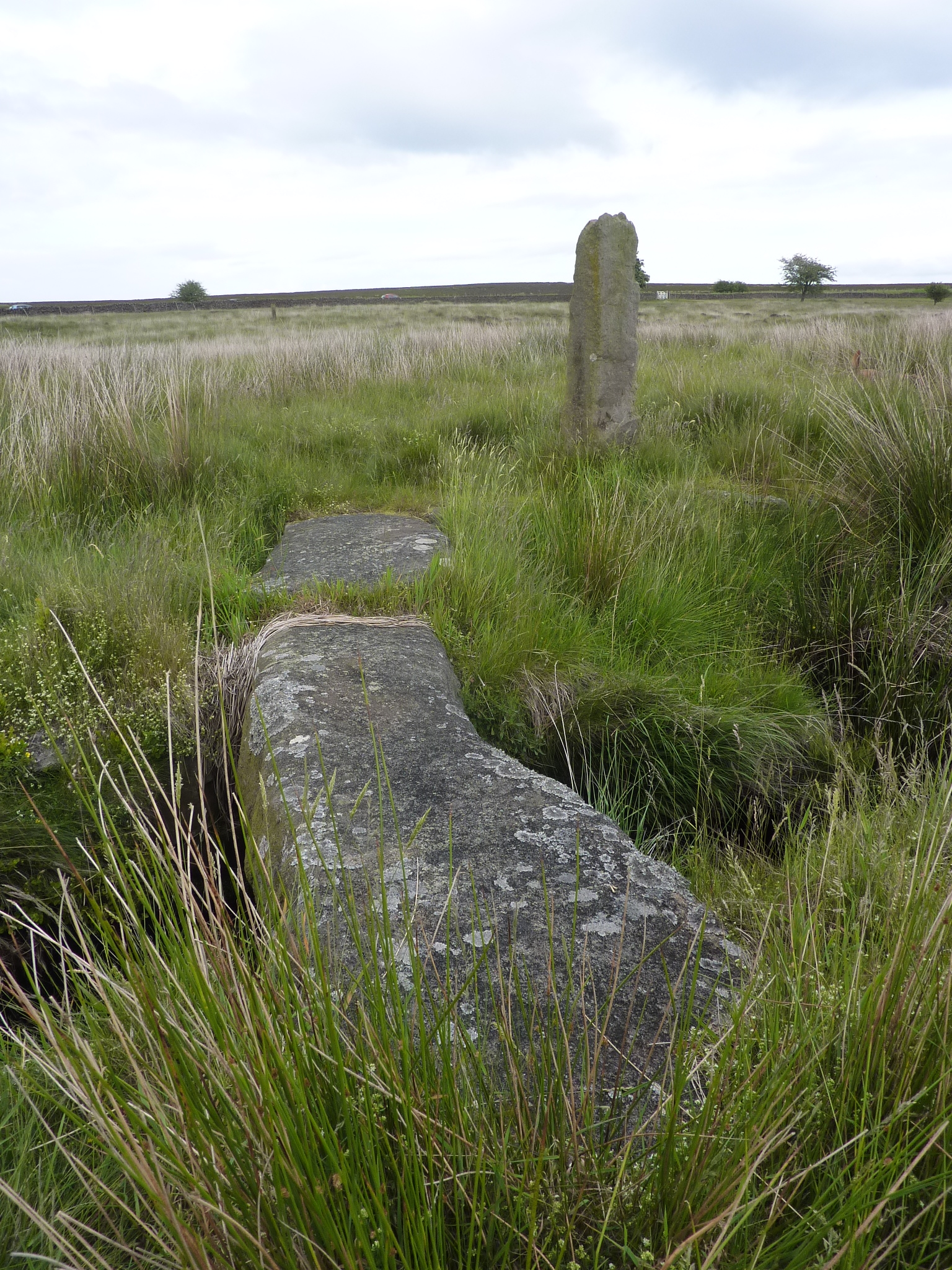
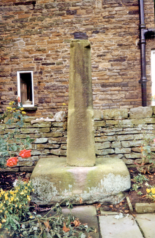
You don’t have to walk very far to see the first remnants of the past history of Curbar. At the car park entrance, walk through the gate towards White Edge, there stands one of the old and ancient guide stoops. Erected by the parish of Curbar in 1709. You will find the name of Humphrey Gregory who was the parish surveyor carved in to the post, along with the directions to various towns. In 1697 it became an act of parliament that the local justices were instructed to erect and maintain guide posts to aid the safe journey of travelers over the lonely and desolate moors. This act did not gather momentum until 1709, when most guide posts were erected.
Curbar Gap guide post.
Before you descend Bar road, take a little time to cross over on to Baslow Edge. There you will find a viewing platform that offers superb vistas west over towards Longstone Edge and beyond. Return to Bar road which was altered when the turnpike came into being and the bend at Warren Lodge was constructed. Keep a look out for the Bible Stones, (on your left). There are four of them, but the fourth one eludes most people, and a proper search is required to discover it. These were all constructed by Edwin Gregory, mole catcher to the Duke of Devonshire. See previous post dedicated to the Bible Stones and Gregory for more information.
If you take notice of the landscape, you can still trace the outlines of the old packhorse routes. Now deep hollows in the landscape.
As you arrive at the sharp left hand bend you can’t help but notice the large house with the magnificent views west, over towards Longstone Edge. This is Warren Lodge, built 1877, and once a gamekeepers Lodge for the Duke of Rutland. So named because of the large rabbit warren that surrounded the lodge.
After the great 1927 sale, it eventually in later years became a Wardens house in the early eighties for the Peak District National Park. It stood empty for several years before finally being sold off around 2005. It is now in private ownership.
Hay making below Warren Lodge
There is an interesting large boulder on the boundary of this beautiful property with a strange carving, no one knows what it signifies. Sometimes symbols to ward off evil spirits would be carved into homes. The boulder is thought be part of an old crude shelter for one of the stonemasons who worked beneath the edge. There is another stone shelter within Curbar Woods. This is known as, “Heidis Hut” but its location will remain a secret to to preserve its integrity.
A surprising fact, was the cost of transporting millstones, for instance, in 1500, the cost for transporting a pair of millstones over Baslow bridge, was 6s 8d.
carving on boulder
Immediately below Warren Lodge and which predated the lodge, was an old croft which can be spotted on the 125:000 OS map. Shown as a small square in the line of a wall. The only information that I can find for this now ruined cottage and farm, is that it may have belonged to a Mr Peat, (nicknamed Black Jack) head gamekeeper to the Duke of Rutland after his fathers, (Edward) decease who moved into Warren Lodge, and remained there until his death.
You can still see the foundations, fire place and some walls of this derelict cotttage.
Croft below Warren Lodge
Retrace your steps to Bar road and follow it down. Before long you come to a water trough to your left. Here you will find the first Bible Stone, the rest being further up Bar road. Carry on descending until you reach the riding stables and go left on the footpath, over a stile and several gates. Keep the wall on your right, until you reach a stone squeeze stile, from there keep on the usually muddy footpath that now rises away from the wall, and you should find the Cundy graves.
First Bible stone.
The five flat stones are individually marked with the initials of the family members who sadly perished in one of the many plagues that blighted England and Europe over the centuries. This particular plague visited Curbar in 1632, thirty four years before the infamous plague of Eyam.
Thomas Cundy along with his wife Ada and three children, Olive, Nellie and Thomas, all perished in this plague and lived at Grislowfield Farm a quarter of a mile away.
Memorial stone next to the Cundy graves.
Retrace your steps until arrive back at the squeeze stile and take the gate on your left. Follow the footpath, dropping down through a small field. You will shortly come to a most unusual shaped building. This square building with the stone conical roof was once the village lockup, securing prisoners overnight between Derby and Sheffield assizes. It was also rumoured to have housed prisoners from the English civil war.
The Lockup
There is also the story of, “Pelly the sailor” who apparently lived here in the 1920s. Here is a photo of him on the roof, holding on to a weather vane of a Galleon. The building is now in a private garden and there is no direct access. Follow the track over a stile where you will return to Bar road.
Opposite, you will see a road called The Green, take a leisurely walk down here, taking in all the different original and unique dwellings of Curbar. One building, now called, “Crifters” was once thought to have been the pub known as, “The Bulls Head”. As you near the junction of The Bent, you will notice a house boundary made up of upright oblong flag stones. These are known locally as, Moonstones. There are numerous Moonstones around the fields and properties. I have not as yet, managed to find an explanation for this name.
Moonstones
On the junction you will notice one of the most unusual structures of any Peak District village, The village well. This was the main water supply for the village up until around 1906, when piped water was first introduced to the village. It is a dual purpose well, with the area for human consumption enclosed within a walled area of Moonstones, this ensured that non of the animals could contaminate the supply. This is covered by a characterful stone shelter with twin doorways. The animals drank from a large stone bowl, hewed out from the local gritstone sited below the human supply, shaped like a millstone, with the water rising from below.
The village well, complete with Monty and Murphy.
The Wesleylan Reform chapel is a stones throw away and was built in 1861. Constructed from local gritstone and attached to the row of cottages built 1848/50 for the workers of the cotton mill at Calver. They are now known as London Row, but once upon a time they were referred to as Club Cottages, for at one time they belonged to Calver burial club, founded 1878. With an annual subscription of 2s 6d you would be assured of a proper burial. Calver cotton Mill was used when they filmed the popular TV series, “Colditz” as the main set.
From the well, go down The Bents, and you will shortly come to the Mullions on your left. This used to be one of the two village shops, and sold everything from food to drapery supplies. This also belonged to the Duke of Rutland’s estate. One of the past owners was Mr and Mrs Ellis. It is recorded at the end of the 1800s, that a John Ellis kept 50 plus sheep on the moors and had started shepherding for his father at the age of seven, not unusual for those days.
Retrace your steps back to the well, turn right down Pinfold Hill, again numerous old dwellings adorn both sides of this road. As you reach the bottom and the junction with Curbar Lane, you will see the Pinfold directly in front of you. Most villages had a Pinfold to collect stray animals. These would be kept by the Pinder. This position was awarded to the Parish during the enclosures act. The price for recovering a stray beast was not a cheap affair, for example in 1720 the cost was around 6s 8d.
Curbar Pinfold
Continue your descent of Bar road to the junction where in front of you stands, “The Bridge” public house. Much altered in recent years, from the characterful interior of yesteryear.
It is on this junction that our final building worthy of mention stands in Curbar, “All Saints Church”. Consecrated in 1868 at a cost of £2,000, and built on the land where the landlord of the, “Bridge Inn” had his carpentry workshop. He also did all the carpentry on the church. It is said that he only went into the church once after helping to build it, at his funeral!
Calver, Curbar and Froggatt All Saints War Memorial.
I am sure there is a wealth of further interesting information out there about Curbar, and if anyone can furnish any further information or corrections then I would love to hear from you and include it into the blog.
Acknowledgements.
Peakland Roads and Trackways, AE Dodd & EM Dodd
The Guide Stoops of Derbyshire, Howard Smith
Calver, Curbar and Froggatt, Brian Edwards
Bob James for his help with the fourth bible stone. Bob is the former head warden who lived for a time at Warren Lodge.
Travelling around the Peak was, for hundreds of years a difficult task. Long before our tarmac roads, goods would be carried on packhorses with panniers attached to secure the loads to the animals. The routes of simple dirt tracks, would be carefully chosen to exploit the weaknesses in the landscape for ease of passage. Routes between towns would usually follow the Ridgeways and only dropping down into the valleys to cross rivers via fords, to then climb back onto the highpoint of the Ridgeways.
Traces of these old ways are still much in evidence on our moors. White Edge Trig point is an excellent viewpoint where old Holloways can be scene snaking around the Trig from Owler Bar and dropping to Curbar fields and through the back of the car park on its way down to Calver and Stanton Ford before carrying on its journey to Tideswell.
Below is a photo of the old slab bridge, complete with guide stoop, just yards from the main B6054 that formed part of the old routes across Big Moor.
The Romans were the first to start any kind of road system and many are still evident on the ground today. The Saxon Portways in the middle ages carried on where the Romans left off, and again the routes of most of these can still be traced amongst the Peak District hills.
In the 18th century the demand for heavy goods came into being, with coal, lead and Stone being transported, along with the higher classes increasing use of stage coaches coming into vogue. This all called for a different standard of carriageway to be built.
Often the new turnpikes would follow the route of an existing packhorse route and Sheffield’s first turnpike route ran via Chesterfield to Duffield, (North of Derby) in 1756, and within 25 years Sheffield was linked to Wakefield and Leeds. Other routes included Rotherham and Doncaster, Bawtry, (Inland Port) Worksop, Mansfield, Tideswell and Buxton, Manchester and Halifax via Penistone.
One such carriageway, or to give its correct title, was the Greenhill to Calver Turnpike which opened in 1781. With all turnpikes, they employed a surveyor, clerk and treasurer. Funds were raised by investment by people from all walks of life, and run by a board of directors. Government control was very strict on how these would operate. They were allowed to erect fences, gates and toll bars to collect the various fees.
Starting in Norton at Little Norton Lane, it then went on to Greenhill village, where an original milestone can still be seen near to the modern telephone exchange entrance.
From Greenhill village you can follow the route up Hemper Lane, (formerly called, Hempyard Lane), you can probably speculate as to what the business was from the name.
The next junction is Tinkers Corner, (named after a, Mr Tedbar Tinker) where in the farmyard of Bradway Grange farm, remnants of an old stone cross resides. This was saved from destruction by road builders in C1938/39 by the then owner of the farm, a Mr T.T. Osbourne who succeeded Mr T. J. Tinker.
This old cross used to stand by the junction of the ancient bridle roads of, Holmesfield to Totley just inside the wall corner, at the junction of Broadway House, Broadway Bank and Totley Rise.
The cross is thought to be one of the boundary markers for the old Beauchief Abbey lands, but it has been dated as a 17th century cross which is after the Abbey was dissolved in 1537. It is more likely to be a, “Travellers Cross” built by the church for the burial party to rest and say prayers while on route to Dronfield as Dore and Totley had no burial grounds back then. also a couple of local tracks used to be referred to as corpse roads.
The cross in the yard of Bradway Grange farm.
The next part of the journey takes us towards Dronfield Woodhouse where at a farm entrance, the next milestone can be seen on Rod Moor road. This milestone should read Gleadless 5 miles.
Rod Moor Milestone
If you do a quick diversion, left down Carr Lane you come to the very ancient 13th C Dronfield Woodhouse Hall with its fine crucks still in evidence.
In 829AD the great Mercian army of King Egbert marched through Dronfield Woodhouse on its way to meet the Northumbrian armies of King Eanred. There now stands on the village green in Dore a commemorative stone to celebrate the meeting of these two great Kings. Fortunately, the two Kings settled their differences without having to fight.
The journey soon starts to climb steadily towards Holmesfield which was mentioned in the Doomsday book, and also after the Norman conquest, had a wooden Motte and Bailey castle. The mound upon where it stood still survives to this day but is on private land. You can see it marked on the modern day OS maps.
The next surviving milestone is just outside the Holmesfield boundary on the first left hand bend, part buried in the undergrowth near to Goosberry Farm, but is still visible.
As we travel onwards to Lidgate, we pass the old Robin Hood public house. This was most probably built to serve the turnpike road in the 1780s. After another 0.5 miles we find another milestone, again on the left hand side. You will have passed Pewit Farm, (Pewit is the old name for a Lapwing), A little bit of history behind this old farm. In the early days of folk beginning to go out into the countryside, Pewit Farm ran a small cafe mainly for the passing cycling clubs. It is long gone now, but I personally remember passing it as a child. A large detached house now stands on the land.
Lidgate, usually refers to an enclosed lane that led in to or from a village. The Holmesfield Court Rolls for 1491 mention, “Chapel Lydzatte” as a wayside Catholic Chapel or Shrine, for the Lidgate hamlet of today, which stands at the boundary of of the old enclosed lands of the pre 1816 common lands of Holmesfield parish.dx
At the junction of the meeting of the Totley road and the Holmesfield road we find the modern building of the Moorlands restaurant. It is at this point that the original toll bar and turnpike gate was built around 1781. In 1837 the toll bar came into disuse when the roads were altered to enable one toll bar to take the tolls from both roads, and went on to become a private dwelling. It was finally demolished in October 1932. The existing building below the current Peacock Inn became the new Toll Bar. The Peacock Inn originally was built by the Duke of Devonshire and was known as the , Deveonshire Arms, but it was sold to the Duke of Rutland around 1820 and changed its name to the Peacock. The Peacock is the crest of the Manners family.
The old Turnpike gate posts can be seen on Moorwood Lane, between the Robin Hood and the Moorlands.
Modern day, Peacock InnPeacock Inn before the road alterations.
Continue around the large roundabout and take the Fox House rd, (B6054). There is a series of bends, go over Saltersich bridge, and just after the road straightens out you arrive at a lay-by on the left, opposite a small gas terminal complex. If you park here, and continue walking towards Fox House you will discover the next milestone.
Take time to take in the expanse of Big Moor, reaching far into the distance on the left. This moor contains a complex of old cart roads and tracks that preceded the turnpikes. These were documented by GHB Ward from his conversations with the old shepherds and farmers of the district and he produced a hand drawn map outlining them all.
After taking in the grandeur of Big Moor, continue your journey, with Totley Moor and the Totley Tunnel air shaft visible in the distance. As you come to cross the Barbrook Bridge, you may notice a stump on the high ground to your left. This is an old wayfarers cross, (damaged). This was one of several in the area that marked the route and boundary of Beauchief Abbey.
Cross the Barbrook Bridge and approximately 1.6 miles from Owler bar, the next milestone is visible by the drystone wall on the left.
Continue to the Wooden Pole road junction. There has been wooden poles erected at this spot for centuries, and at least from 1550 when the first recorded pole was documented. As well as a distance sight post it also marked the boundaries of Holmesfield and Hathersage. There is an inscription on the base which reads, T778TW. (Thomas Willoughby, Owner of Manor of Totley).
The original parish boundary stone can be found under the dry stone wall that forms the boundary of Totley moor, opposite the junction to Froggatt and Calver.
Turn left, signposted, Calver. The next milestone is a little harder to find, and I had to do a little bit of gardening to find it. Slightly raised on a bank on the road above the entrance into Longshaw, GR SK259783, sits the penultimate milestone. See if you can find this one.
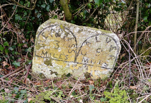
The final surviving milestone is very difficult to access, as there are no footpaths and it sits between the edge of a very busy road and the steep boulder strewn hillside of Froggatt Edge. It is damaged, but reads, GLEADLESS 12 MILES, CALVER 3 MILE.
As you progress down towards Calver , you come to the ancient inn named , “The Chequers”, built between 1550 and 1600, on the Duke of Rutlands land, by the Hallam family, of Calver. At this period, it stood on the old packhorse route that came up from Froggatt bridge and climbed up over Froggatt Edge. It was rebuilt in 1735, also joining four cottages to the building. at a later date in the 1950s it was again extensively rebuilt to become the Inn that we all see today. The name derived from the overseer of the parish, sitting in there, collecting the rates from the locals.
Damaged troughs, south of the Chequers Inn.
Just south of this lovely old Inn, there used to stand another milestone, but this is lost in time, possibly removed at some time due to roadworks. It would have read, GLEADLESS 13 MILES, CALVER 1 MILE.
Again below the Chequers on a right hand bend at the entrance to Bee Wood you come to a large old stone water trough, damaged, but still in situ.
At the crossroads below Bee Wood, marked Curbar to the left, Froggatt to the right, There was a Toll House. Dating from C1781, it was eventually bought by the Duke of Rutland estate in 1880 when the road ceased to be a turnpike and is still there as a private residence, although, extensively refurbished over the years.
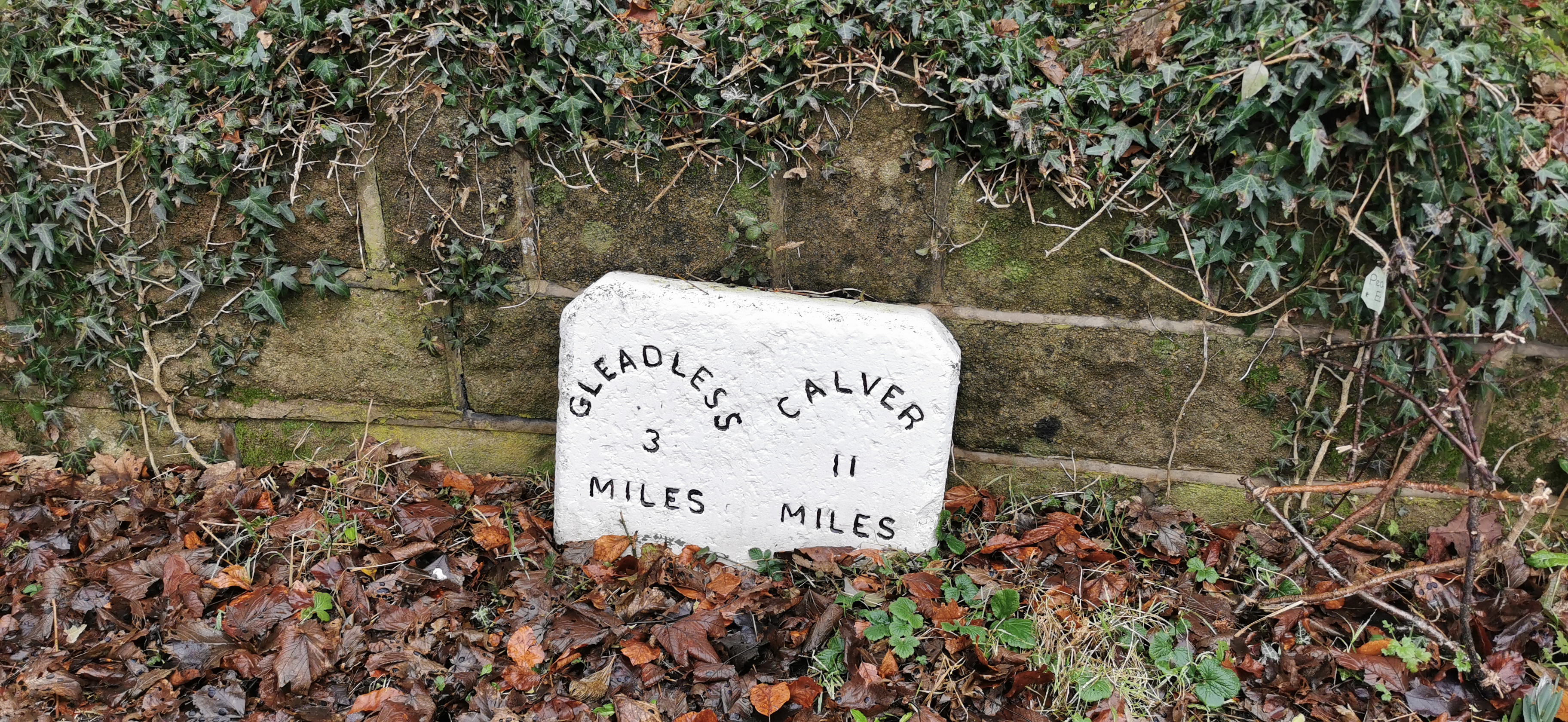
Continue on you way, following the B6054 and you shortly come to, “New Bridge”, built in 1781 for the turnpike. A third of a mile further on you reach your destination and the terminus of the Greenhill to Calver turnpike. The total distance in 1781 was 11 miles and after 1825, from Gleadless, 14 miles.
Acknowledgements:-
GHB Ward for the map of Big Moor.
Howard Smith for his Turnpike Trail booklet, which provided some of the information.
Neville T Sharpe for information around Lady Cross in his, Crosses of the Peak District, book.
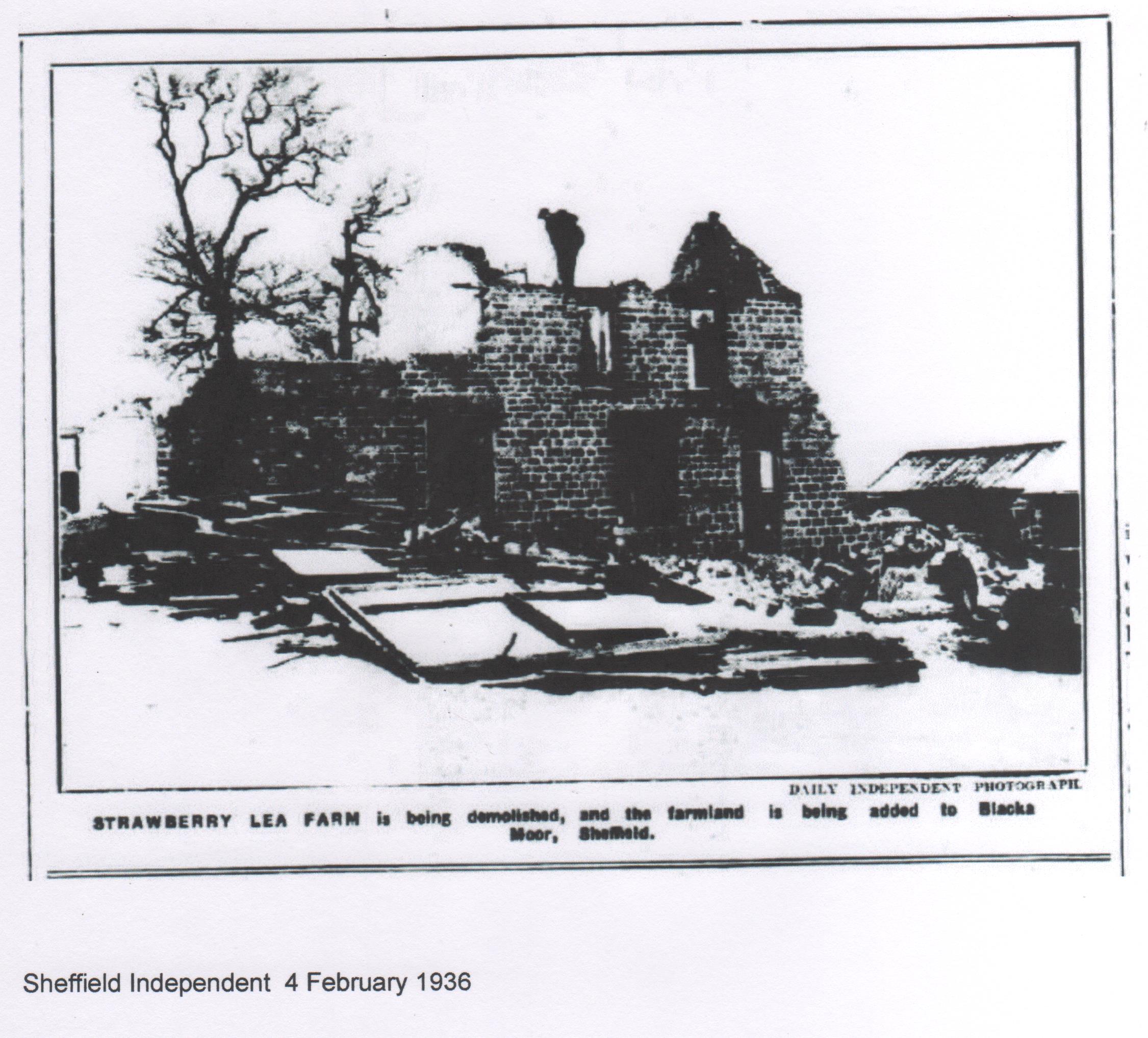
The site of,(Streberyley), Strawberry Lee farm lies silent in the folds of a natural amphitheater, sheltered from the harsh winds of the high moors within Blackamoor.
Purchased in 1927 from the former, “Grouse King” the Duke of Rutland, by Councillor Dr G. H. Froggatt of Sheffield for £6,000. By 1931 Blacka Moor was again up for sale after plans to develop it were thwarted by Sheffield Council.
It was in 1933 when that great benefactor of the people of our City, Alderman J. P. Graves stepped forward and bought the 448 acres of Blackamoor just one of his many gifts for the people of Sheffield. The cost was £9,000 a great sum of money in 1933.
The remains of the farm
The history of this very ancient site goes back to Beauchief Abbey and Strawberry Lee Grange an outlying farm of the Abbey. In Pegges rare, “History of Beauchief Abbey” the ancient name for this monastic outlying grange of Beauchief Abbey was, Streberiley.
Totley Moss and Blackamoor was in 1263 a monastic grazing ground given to the monks by Matthew of Hathersage, the then Lord of the Manor. Gifts like these to the Church were often given to ensure your safe passage to heaven, Matthews gift was no exception.
The dozen Premonstratention Monks, (White Cannons) and their Abbott, first settled at Beauchief Abbey in 1183 and owned the surrounding areas of, Greenhill, Totley and Bradway. They were eventually to own vast parts of our moorlands in later times, all donated by landowners which enabled the Abbey to become very wealthy.
With the quarrel in the 16th century between Henry VIII and Rome raging, and with the final act of the dissolution of the Monasteries, Church lands all over the Kingdom were divided up to the local Nobles and Squires.
The earliest reference to the leasing of land around Strawberry Lee and Blackamoor was in 1461. A John Faunchall, probably of Fanshaw Gate Hall, was granted a 60 year lease for an annual rent of 14/-, which in 1937 equated to around £20. The last known lease was granted in 1530 for 70 years at an annual rental of 6s 8d. This all ceased with the dissolution of the monasteries in 1535 with Henry VIII fallout with Rome and Henrys carving up of the lands and properties to his chums.
Sir Nicholas Strelley was one of these nobles and on the 10/04/1537, bought for a payment of £223, the monastic lands and buildings of Beauchief Abbey. The succeeding owners the Pegge-Burnell family held the land until the Duke of Rutland came along and started his quest of land ownership for the sole purpose of raising Grouse for his so called sporting moors.
As with a lot of the old bridleways and buildings that came into the ownership of the Duke, they quickly, through blatant neglect, fell into disrepair and eventually ended up as the inevitable ruin. The only ones to survive to this day are the ones that were built by the Duke as his gamekeepers lodges.
Sometime in between 1820/30 a new farm was built by the Pegge-Burnell family, possibly on the site of the old Monastic Grange. No doubt some of the stone was recycled into the new buildings. More of the old stone from the Grange was sold in and around 1870, to build the new Dore road and some more for the local field boundary walls.
Former water spring
GHB Ward who as a child on New Years day in 1881 had been taken to the farm with his Fathers,”young men’s” class, a time when Tommy Mottram kept the farm. It was finally demolished in 1936, and all that remained was the farm yard. The local rambling community were shocked when they discovered this blatant act of vandalism by Sheffield Council. All that can be seen today of the farm is the raised archaeology of the remaining stone work. Sadly this was happening all around our moorlands. Higgar Lodge, Badger Houses and Piper House to name a few were to suffer the same sad fate.
Strawberry Lee farm during demolition in 1936
Tommy Mottram was a well known local character who won fame for his knitting skills especially stockings. He taught one of the Daughters at Stoney Ridge Toll Bar, (see previous Stoney Ridge Toll Bar) to knit and were close neighbours. He would also make hearth rugs, from strips of old materials, something I remember from my childhood as peg rugs usually sat in front of the Yorkshire Range. He would travel to Scotland and drive back good stock of Scottish sheep. Travelling along the ancient By-ways and Bridle-ways, all the back to Strawberry Lee Farm, only losing a few on the long journey back home. A testament to his good shepherding skills. One disadvantage that Tommy had was a fine set of bowed legs. Many a sheep escaped his clutches, by diving for the gap between old Tommy’s legs.
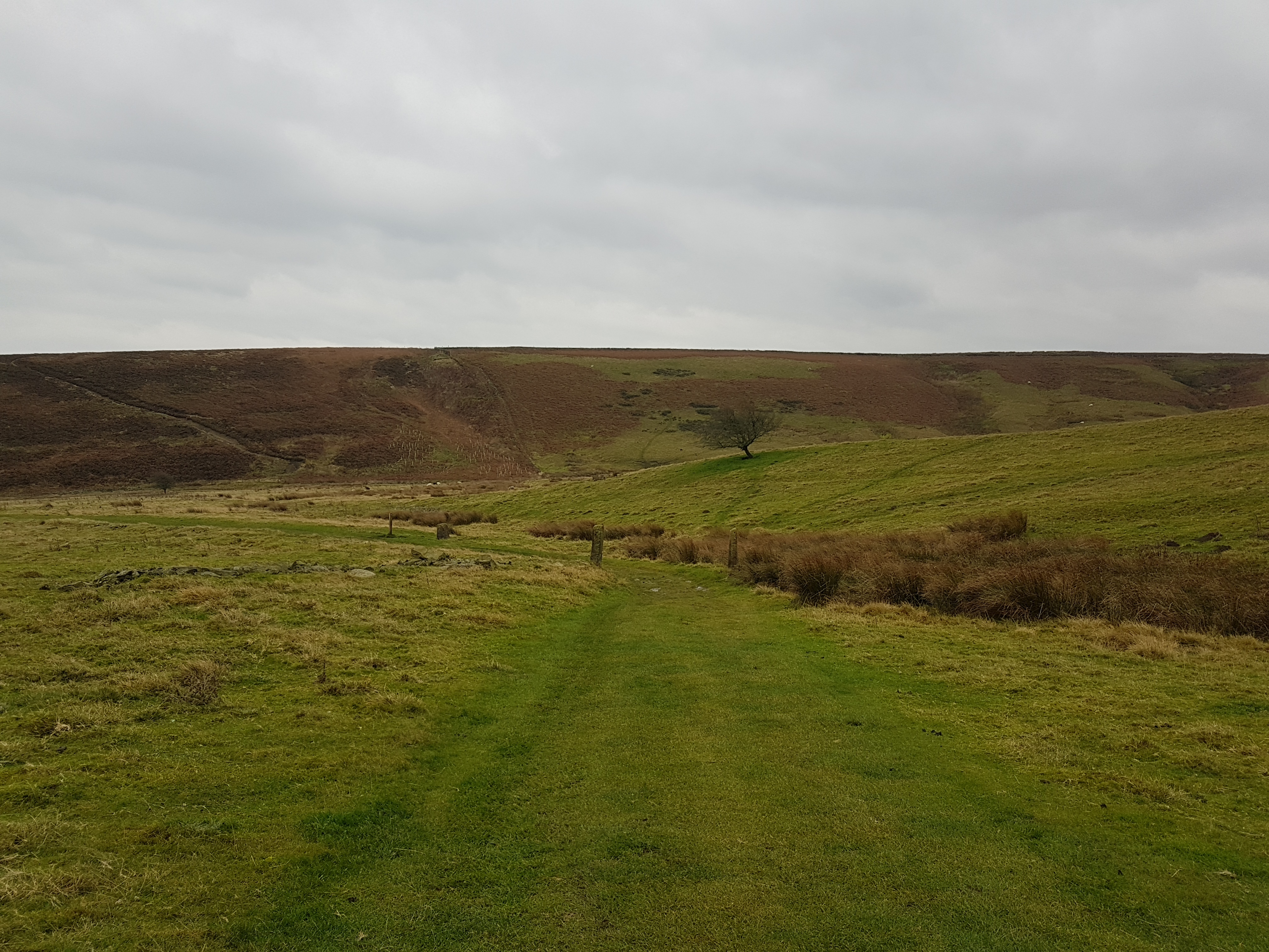
The old, “Monks Path” went from the Cross Scythes Inn down towards and pass the Cricket Pub and onwards up the Moss road to Totley Moor. Halfway up the Moss road you take a sharp right, contouring down and around Wimble Holme Hill, which takes you gently down to the once spectacular site of Strawberry Lee Farm. Today it is a challenging piece of single track for the mountain bikers where the walkers have to be alert to the speeding modern bicycles.
The track from Stoney Ridge to the farm.
During the tunnelling of the Totley to Grindleford tunnel, the many Navvies employed upon this mighty task, caused the locals quite some concern and Tommy was always on watch. On one occasion the Woodsman from the Beauchief estate was sent to spend a few days with Tommy to help him guard against any thieving from these rough workers. Tommy bought in a small barrel of Berry’s, “Strike-me-Stiff” to keep them company. On the second night a commotion could be heard coming from the hen roost. On investigation two Navvies were seen to be helping themselves to Tommy’s Hens. During the ensuing, slightly inebriated, scuffle the Navvies were able to slip the gauntlet and run away. However Tommy had a small Pin-Pistol and he let rip right into the second Navvies backside as he was climbing over the back yard gate. The Navvy was last seen to be running down the hill screaming holding his peppered backside. A couple of weeks later Tommy was in the Cricket pub, having a few jars until well after time. On walking back up the lane towards home and through the gate on to the open moor, a burly figure stepped out of the shadows, it was the navvy that Tommy had previously shot.
The Navvy was determined to get his own back and threatened to, “do him in” for shooting him. In the words recorded by GBH Ward in the 1937/38 Clarion Ramblers handbook tommy said, “Well ah may no moor to do bur ah crack’d him one o’er t’eead wi mi ashplant, an’ ah down’d ‘im an’left ‘im. Ah went dahn t’next mornin’ ter see if ‘ewer still theer. Oh ‘e’d gone reight enuff. but ther’ wer plenty o’ blood abaht.
Construction on Totley tunnel began in 1888, and was when first built the second longest tunnel in the U.K. 3.5 miles in length. The Severn tunnel was 0.81 miles longer. Totley tunnel is now the longest wholly underland tunnel in the U.K. During construction the Duke of Rutland decreed that only one ventilation shaft would be allowed on his land and the construction on his land had to cease between August and October for the Grouse shooting season. The Navvies lived and worked in desperate conditions and work carried on twenty four hours a day, with retiring workmen swopping beds with others has they arose to go to work. The filthy damp conditions were a breeding ground for Typhoid, Diphtheria, Smallpox and Scarlet Fever, indeed old Tommy caught Smallpox from the Navvies in around 1902 and his housekeeper, “Kitty” died buried in a snow storm while returning to Strawberry Lee from collecting groceries at Totley Bents. She was only found a couple of days later by Dr John Aldred. In paying his patient a visit he noticed a hump in the snow and poor old Kitty was found quite dead buried beneath the mound.
Tommy was also one of the originators of the local Longshaw sheep trials in 1898. A tradition still carried on even to this day at Longshaw. He also shepherded one of the largest flocks of sheep in the district.
Long before machines came to ruin the idyllic ways of the country man, all the locals would converge on Strawberry Lee to help with the shearing. When all the hard work was done a big supper and sing song would ensue, and it is recorded by GHBW that, “didn’t they put some beef and ale away”.
Tommy was a true local character to which you would be hard pressed to find these days. Tommy ended his days at Strawberry Lee farm, and was probably the last shepherd to live at this remarkable old site. Tucked away in the peaceful valley, even today it is a place of real solitude and well worth a visit especially on a warm pleasant day.
This story could not have been told if it was not for the magnificent efforts of George Herbert Bridges Ward and his determination to speak to the old shepherds and farmers in the early years of the 20th century, and his diligent recordings in the Sheffield Clarion Ramblers Handbooks, of these marvellous old and now sadly gone places on our moors. I for one will be forever in his debt.
I am also indebted to Thelma Griffiths, a volunteer at Longshaw NT who kindly supplied the only photo that we think exists of Strawberry Lee, sadly it is of its demolition in 1936. You can see the two workmen adhering to strict H&S working practices.
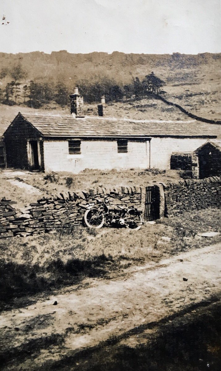
In the 1943/44 edition of the Sheffield Clarion Ramblers Handbook, Stanage Cottage is described as a lonely little cottage of grey gritstone, standing in a small croft below the windswept firs of forlorn Stanage Plantation underneath Stanage Edge. Stone Edge/Stanedge are also old former names. You cannot miss it as you come down Golden Carr bridle track.
Above photo taken around 1927
What a different story today. You would be hard pressed to notice the remnants of Stanage Cottage. It may catch your eye if you have ever visited the toilets, (the old Mountain Rescue post and Ranger Station opposite) and on your way out again. But again no one thinks that these gate post ever led to anywhere other than a lost path onto Stanage Edge. If it was not for the old gateway gritstone posts you would never know that it ever existed.
All that is left
Wildlife garden
Looking from the old garden
Thought to have been built sometime around the boundary awards days of 1808 to 1830, and possibly for the first gamekeeper, (Furniss) whose area included White Path Moss, which stretches from Stanage Plantation to Cowper Stones turning to Stanage Pole. From there it follows the county boundary and water shed called Friars Ridge and terminating at the Sheffield boundary marker of the North Burbage bridge. In all the area covered an around 600 square acres.
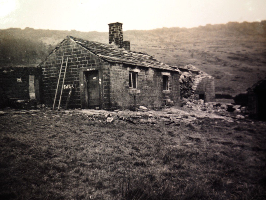
Part demolished in 1943
Demolished sometime around 1946, today not a trace remains of the walls or any other remnants other than the two lonely gritstone gate posts. The footprint of the old cottage has now been turned into a wildlife garden complete with a couple of benches, where you can rest and try to lose yourself in quiet contemplation, and put the World to rights.
When GHB Ward first wrote an article on Stanage Cottage in Autumn of 1912, it was known locally as Hugh Thorpes Cottage, who had been the Gamekeeper, but had died several years previous to this visit of Bert’s.
The local name for Stanage Cottage was Bandy Cock Hall. I have never read an explanation for this so would be interested from anyone reading this blog why it was known as such.
Before the enclosures act of 1808, White Path Moss and Sheepwash Bank down to Greens House/Mill, (more of that will be in a future blog) was common land. Thereafter it became the domain of the grouse and the game keepers. Bert Ward talks about shady dealings with people selling on their enclosure awards even before they had been awarded. Nothing changes there in the great and corrupt halls of the old boys club.
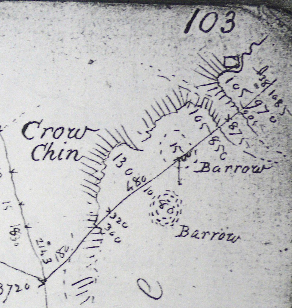
The area around Stanage Edge started to be populated in the early Bronze age as the temperature increased by several degrees, and made arable farming a more viable proposition in this wild and rocky landscape. Clearance cairns are evident, and Dennis Knoll and Sheepwash bank have given up several traces of our ancestors buried in burial cairns. A large barrow was discovered on Crow Chin. The skeletons of our ancestors would be usually buried in the foetal position, and David Hay in his book, “The History of the Peak District Moors”, suggests that bodies would be placed in the clefts of the cliff face to be left to the elements, a practice still practised in some parts of the world. These finds have been dated to 3,000 to 4,000 years old.
On the 16th October 1932, a planned trespass on Stanage was thwarted by foot and mounted police with Alsatian dogs. At this time Stanage moors, (2,000 acres) along with Stanage Lodge, had been purchased in 1869 from the Duke of Norfolk by William Wilson of the still thriving Wilsons Snuff Mill fame, based off Sharrow vale road in Sheffield. The sale was advertised as, “The finest sporting estate ever offered in the Sheffield District”. It was William Wilson who commissioned in 1907 the first of six drinking troughs to be hewn out of the natural rocks that surrounded the moors of Stanage. A young mason, George Broomhead, was given the job. George was born in 1893, so would have been fourteen at the time, and was according to the accounts book, paid 7s 3 1/2p per bowl. It was such a success in William Wilsons eyes that he commissioned a further seventy five. Five have been lost to nature and sunk into history. Another row of twenty seven less well known basins, carved again by George but now more skilled, can be found in Oaken Clough but these are much harder to spot in the overgrown landscape.
Acknowledgements
Many thanks to George Herbert Bridges Ward for his massive contribution to collating the lost history of our Moors and its people.
David Hey for his, “A History of the Peak District Moors” and “Historic Hallamshire”
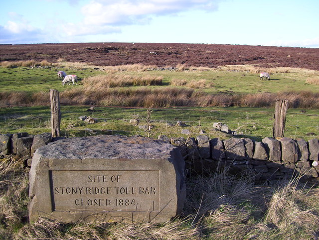
All that remains of this old Toll Bar is an inscribed stone tablet situated at the side of the road near to the present junction of the Fox House and Stony Ridge road Junction. The Stoops or gate posts that use to span the road that carried the bar have been long removed to Whitelow New farm on Whitelow lane. This Turnpike was constructed in 1812 to replace an earlier one that went across the moors behind it.
Road Tolls ended here in 1884, and Sam Barton was the last Toll bar keeper at Stoney Ridge. He was also a cobbler, which no doubt brought him much needed extra income to supplement the meagre wage of the Toll Keeper. The story goes that he used to white wash his coal, to prevent Gypsies who regularly camped out on the heather covered green of the branch road, from stealing it as he could easily identify the white coal.
Another story was that Sam had a riddle, where he would sift the Toll money through. The 3d and 6d coins would fall through, and the these he kept for himself ,while the larger coins in the riddle went to his master.
Sam Kay, another keeper before Sam Barton, had a side line to collecting the tolls which was a besom, (broom) making business. The raw material existed behind the Toll Bar house on the Houndkirk moor. These were sold to Manchester and Liverpool corporations and more than likely to local villages.
A story from the 1954/55 Sheffield Clarion Ramblers handbook describes how, “Old Tommy Mottram, who was farm bailiff at Strawberry Lee farm, was a famous knitter and spent at a lot of time at Stony Ridge and taught Sam Kays oldest daughter and Aunt how to knit. Sam Kay, (1824-1900) was the Toll bar operator at that time. Sam left Stony Ridge in 1870 to work at another Toll at Wyke near Bradford.
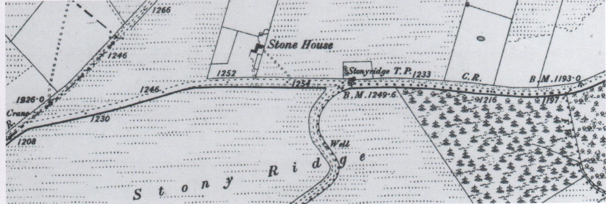
This map from 1842, depicts the old branch road of Stoney Ridge with a bend, but this was later straightened as an improvement to what we see today a straight road. You can still walk the old section and see the surface beneath your feet. Clearly the Toll Bar and Stone House are both outlined on this map. Copy write NLS, (National Library of Scotland)
The last occupant was Mrs Henry Peat. She must have moved from Stoney Ridge house after her husband Henry had passed away, as she could not afford the rent on the larger house with outbuildings. She finally left in 1914 and went to live in nearby Cutthorpe on the outskirts of Chesterfield.
Closed in 1884 and destroyed in 1919 by Sheffield council, this was just one of the many Toll Bars that were placed on the Sheffield to chapel en le Frith turnpike road.
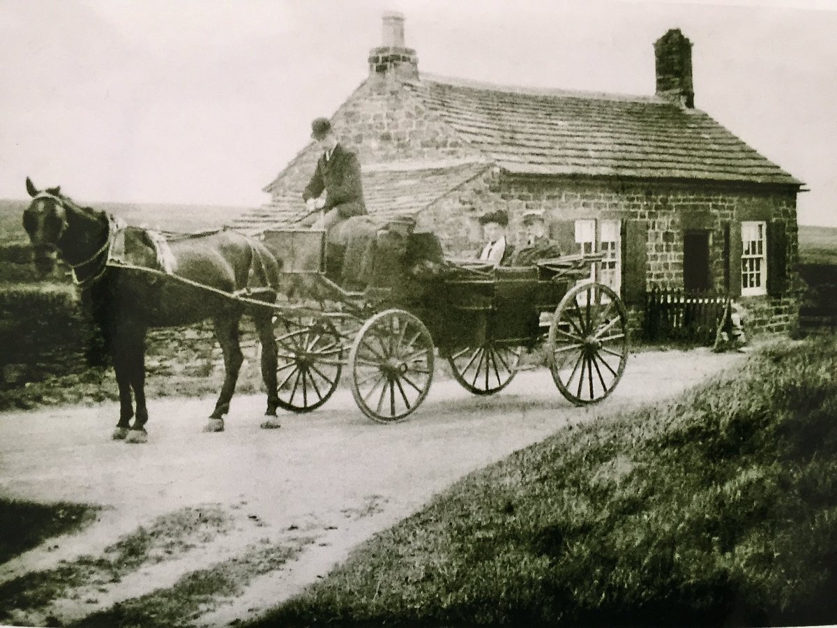
Further on up the road, and on the same side towards Fox House another dwelling existed known as Stoney Ridge House. Built by Henry Hancock of Dore. This was let to Henry Peat who cleared the land and also made brooms in his Broom shop. The records show that Mr George Stone the Corporations keeper of Burbage Moors, lived here until that too was finally demolished probably in the thirties or forties like other moorland dwellings around the Eastern moors.
Today it is a busy arterial road out of Sheffield into the Peak District and further afield. The tranquil looking photo of the horse and carriage outside the Toll Bar, bears no resemblance to the manic speeding traffic that waits for no man today. Sheep and cattle spatter the moors with the odd sightings of the local wild Red deer. The Kestrel hovers above the ancient dwellings ready to drop like a stone on to his next meal. Red Grouse still roam the heather, but not in the numbers that existed when the old Duke of Rutland owned these parts. Their mimicking call of, (go back, go back), is the only clue to the bygone gamekeepers who use to patrol these moors, jealously guarding their masters sport of Grouse shooting. If you were caught on these moors in the time that they belonged to the Duke, the shouting of, “go back” from the gamekeepers would be a polite version of what the likes of GHB Ward would have to endure in his quest to keep the moors free to roam.
Most of this information came from the 1945/46 Sheffield Clarion Ramblers Handbook, and as always I am indebted to Bert Ward for his notes on the old history of our moorlands and the characters and buildings which like most, Stoney Ridge Toll Bar and Stone House have disappeared in to the depth of time.
The above link will take you to the census forms which supplies the names and status of the occupants of the lodge.
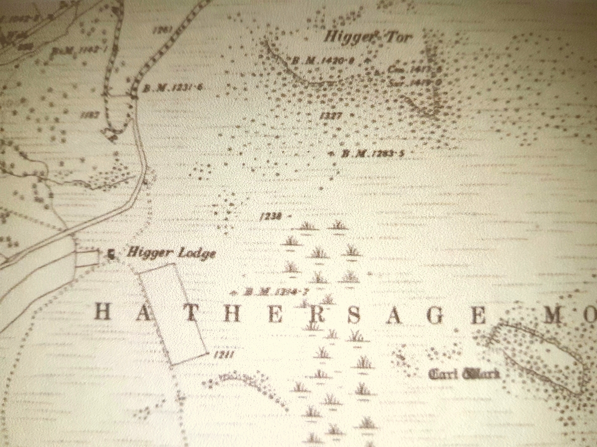
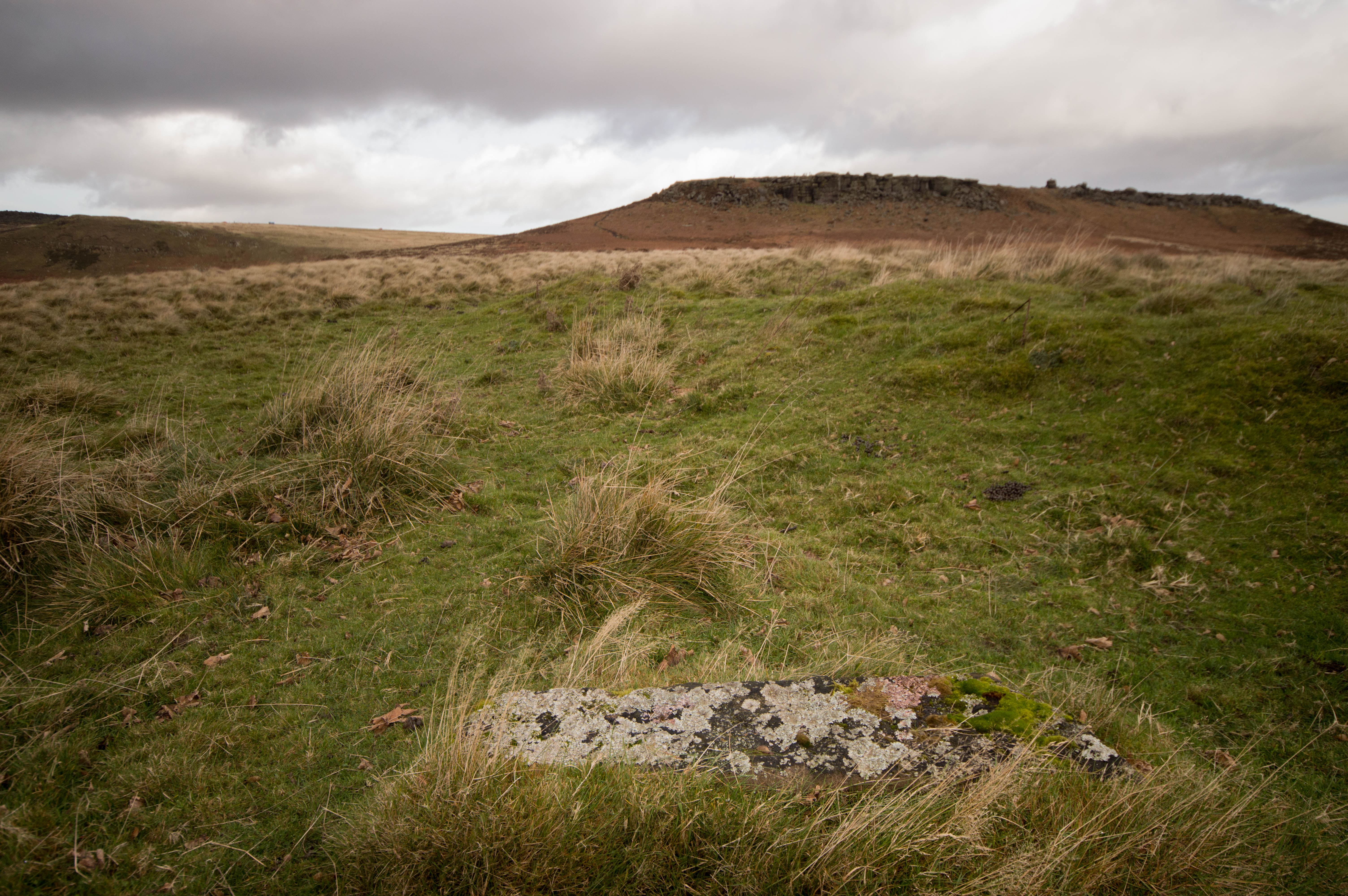
Among the gamekeepers lodges of the Longshaw estate, Higger Lodge to me is the most elusive of the old lodges in terms of historical records and certainly pictures. Very little survives today of any evidence on the actual ground of this dwelling. Sitting on the high ground above the Higger Tor road it commanded a jaw dropping view of the beautiful Hope Valley.
Higger lodge is described in the 1927 sale of the Duke of Rutlands estate as being, stone built and stone slated, with three bedrooms, sitting room, kitchen, pantry and outhouses.
Today all that is left is an obvious raised area of archaeology which gives a rough impression of the size and shape. The stone in the foreground is an obvious piece of worked gritstone that once formed part of the fabric of the building.
The earliest mention of this moorland lodge is in the 1861 census records, (see link at the top of this post) where it is listed as a private dwelling and occupied by William Booker 27 a gamekeeper and his family, Emily 24 (wife), Charles Booker 2 (son), and Joseph Booker 11m (son).
The first census to mention it as Higgar Lodge is in 1871, where the Booker family are still living there, but the family has extended to three more children.
Through the years various families lived there for example Joseph Frost and family, a stone cutter who possibly working in the local quarries of Stanage or Millstone. George Mosley and family, 62. A millstone maker along with his son Joseph 14, also a millstone maker.
The right to roam in the Burbage valley was gained by GHB Ward after consultation with the Dukes agent. This was authorised by prior arrangement and limited to only a handful of people at a time. You were only allowed to walk the Dukes drive, which still exists today, linking the lower and upper Burbage bridges and if you wandered off the track you would be pounced upon by the Dukes watchers and gamekeepers. In 1926 the Priestley family lived at Higger Lodge and they would serve refreshments to walkers until ordered to stop by the then Duke of Rutlands agent.
The advent of the impulse to roam by the working masses, came at the end of the horrors of the first World War. The working man and woman had finally had enough of the restrictions imposed upon them, and after the end of the war, they were not in any mood to be told where they could and couldn’t go. This meant that more and more people were wanting to tramp across the moors and escape the dirt and grind of the great industrial cities of Sheffield, Manchester and Derby. Sometime in the late 30s early 40s, the lodge came into disrepair through vandalism, when the floors and doors were burned by weekend campers. Much the same happened all over the Peak in the many by now abandoned shooting cabins. Grindsbrook cabins suffered similar fates by the youth of the day.
Near to the Lodge there is an enclosed field of two and a half acres. This is one of the five fields ordered to be built by the Sporting Duke to grow black oats in which to feed the grouse. This structure is the only surviving part to Higger Lodge and like most of the other four field enclosures on the Longshaw estate simply survived because they were of use to the sheep farmers to contain and shelter the moorland sheep. As you enter the enclosure you see the now defunct rain gauge enclosure. As you would expect from the days of quality build, it is well made and the gate posts are quite ornate for just a functional piece of equipment.
Sadly just after the second world war, Sheffield council took it upon themselves to demolish some of the Longshaw estate lodges. Vandalized and probably in a sorry state, Higger Lodge was amongst others, sadly one of the victims. Today this would be a much sought after property.
If you go up there today, you will be able to stand in the garden where part of the walls are still visible, and wonder at what life must have been like back in the 19th century. Beautiful warm and peaceful days, with stunning views down the Hope valley that would cost a fortune for the view alone these days. Or the harsh freezing winters, snow and wind driving straight down that beautiful valley with no shelter from the icy blasts.
As always without the documented history from GHB Ward in his Sheffield Clarion Ramblers handbooks most of the history of our moorlands would have been lost.
Thank you to Thelma Griffiths of the NT at Longshaw for information which helped fill in the missing gaps of information.